

The World War Two Fuel Tank Blast Wall, built in 1942-43 for the associated US Marines camps at Paekākāriki, has outstanding historical significance as a demonstration of New Zealand’s role in the allied response to the Pacific War against Japan. It is a rare surviving structure to represent the transformation of New Zealand localities such as Kapiti when they accommodated the US Marines and defence activity. As an authentic example among only three blast walls confirmed to survive, its architectural and technological values show the skill and co-operation of the builders in meeting the defence demands of a top-secret programme in a pressured timeframe. The structure is within the important ancestral landscape of Wainui, significant to mana whenua Ngāti Haumia ki Paekākāriki of Ngāti Toa, with shared interests extending to Ātiawa ki Whakarongotai. Its heritage values are enhanced by its location amidst a historical landscape of the former Kapiti camps, marked by the ongoing commemorative activities of the community.
At the start of the nineteenth century Kapiti was inhabited by Rangitāne, Muaūpoko, and Ngāti Apa, who had intermarried with Ngāti Ira people. From 1822 successive waves of hapū and whanau from Kawhia and Taranaki moved to the region, led by Ngāti Toa chief Te Rauparaha who valued Kapiti’s strategic location for trading with the European whalers who were beginning to frequent Cook Strait. Conflicts between the migrant and incumbent groups resulted in tribal boundaries being redrawn and Ngāti Toa Rangatira, Ātiawa ki Whakarongotai and Ngāti Raukawa ki te Tonga became mana whenua along the Kapiti Coast. European colonisation, and the sale of the Wainui Block in 1859, reduced Māori lands near Paekākāriki to a number of reserves for settlement and cultivations; these were further reduced by subdivision, sale, and seizure by the Crown for public works. Ngāti Haumia ki Paekākāriki have maintained ahikā at Wainui. By the twentieth century the subject land was owned and farmed by Harold Smith, whose brothers had adjoining farms.
The Japanese attack on Pearl Harbour in December 1941 brought the threat of invasion sharply into focus for New Zealand. New Zealand joined Britain and the United States in declaring war on Japan, and New Zealand began hosting US Marines (USMC) in a mutually beneficial arrangement: New Zealand was a strategic staging and supply post for the US Military’s operations in the Pacific, while the Marines strengthened our defences. Three large camps were built at the north of Paekākāriki to accommodate 15,000 servicemen, swelling the small seaside village between June 1942-November 1943. The Public Works Department was also ordered to build a network of camouflaged Aviation Reserve fuel depots around the country, to service planned US air bases. Each bolted steel fuel tank was to be encircled by a splinter-proof blast wall to limit damage from explosions.
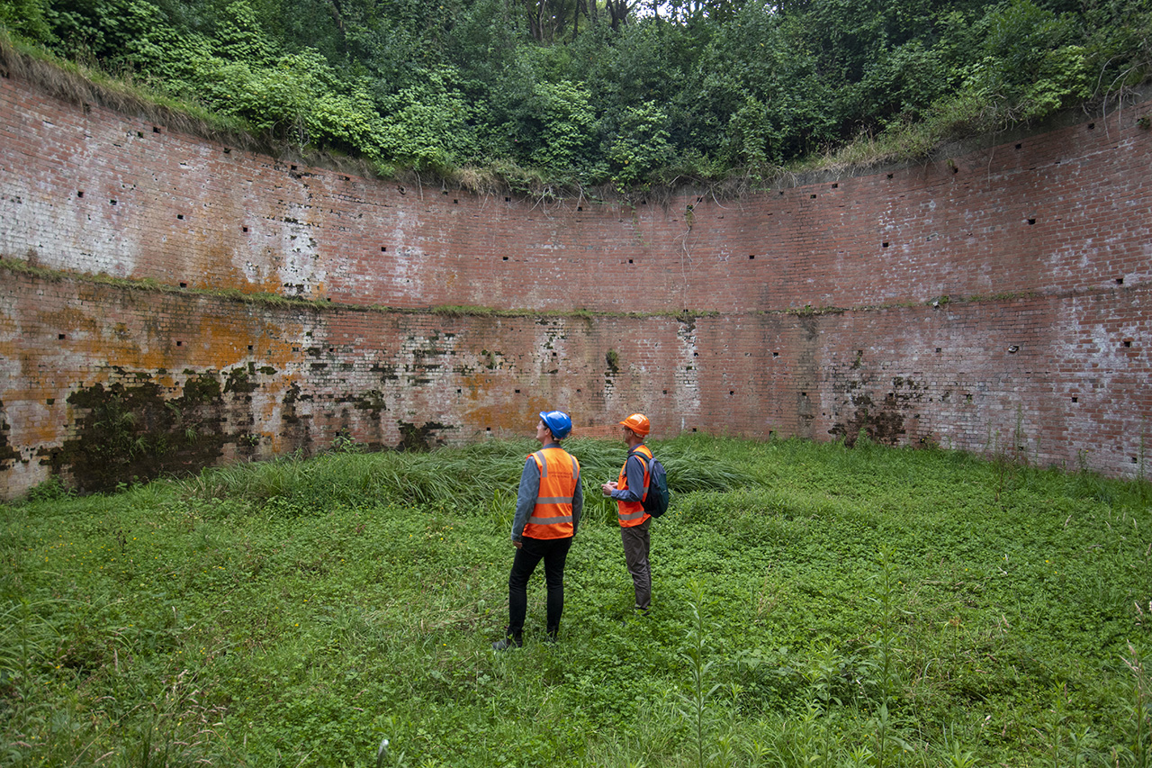
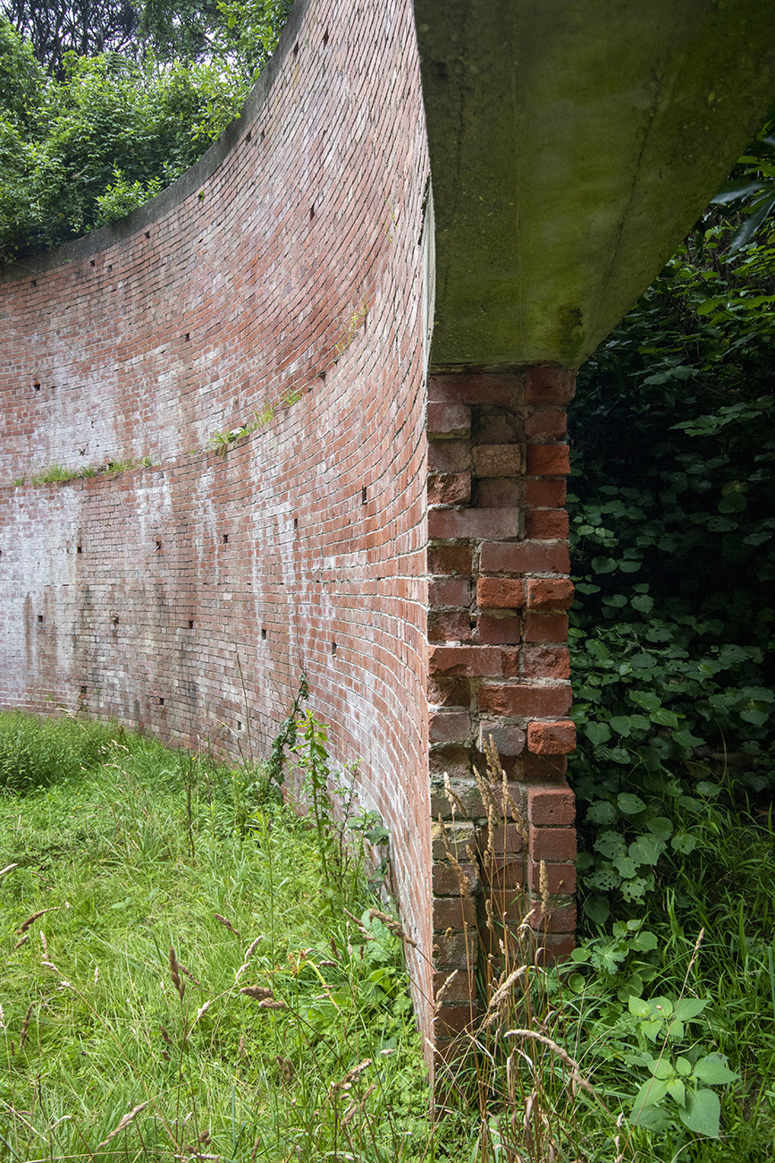
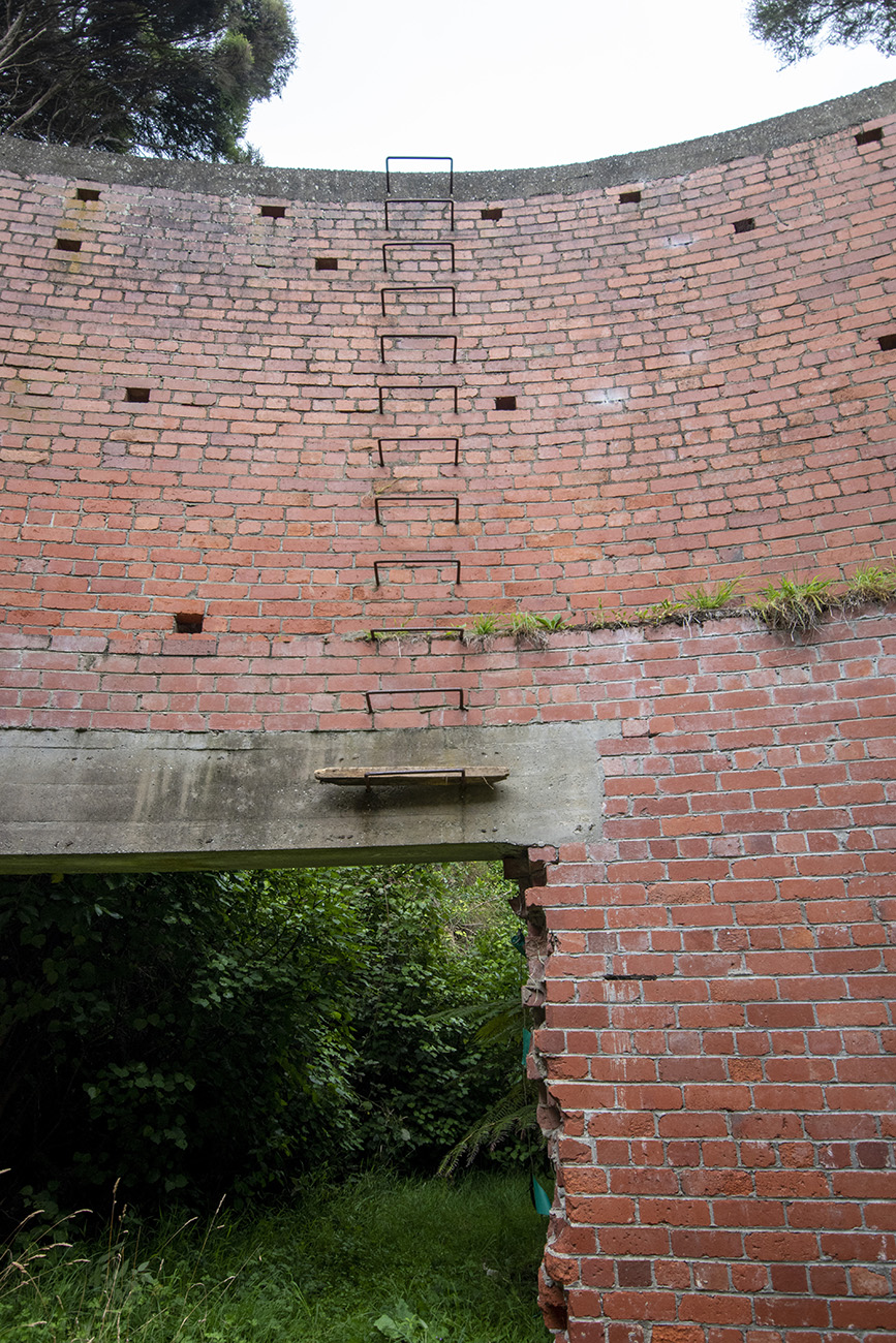
Aviation Reserve 17 at Paekākāriki was started in May 1942 in a valley near the camps. The Public Works department excavated a former meander of the Te Puka Stream and built the blast wall foundations. The 10-metre-high x 18-metre diameter circular brickwork was completed by Love Construction Co. between February and April 1943. USMC Engineers welded and laid 670 metres of fuel pipeline between the tank and a railway siding, and road filling points suggest the installation was uniquely for holding US motor spirits instead of aviation fuel. A bolted 350,000-gallon tank was sent from the USA, but the tank panels were in poor condition and needed preparatory treatment.
However, before the tank could be assembled, all further construction was cancelled on 29 April 1943 due to changing strategic priorities. The PWD resisted orders to return the site to its original state. The suggested reuse of the installation as a water reservoir ultimately came to nothing and it was left in situ. In 2012 the farm was taken by the Crown and the Transmission Gully Motorway built near to the blast wall, which was identified for heritage conservation as part of the project.
List Entry Information
Status
Listed
List Entry Status
Historic Place Category 1
Access
Private/No Public Access
List Number
9869
Date Entered
29th June 2023
Date of Effect
20th July 2023
City/District Council
Kāpiti Coast District
Region
Wellington Region
Extent of List Entry
Extent includes part of the land described as Lot 1 DP 368307 (RT 277518), Wellington Land District and the structure known as World War Two Fuel Tank Blast Wall thereon, including a curtilage of 5 metres around the circular structure and extending approximately 20 metres west towards the edge of the farm track near Te Puka Stream, to encompass the outer sump and its outlet pipe, and the approximately 10 metres of remnant fuel pipeline visible north of the outer sump in the track embankment. (Refer to map in Appendix 1 of the List entry report for further information).
Legal description
Lot 1 DP 368307 (RT 277518), Wellington Land District
Why is this place significant?
Cultural Significance
Cultural Significance or Value The structure is located in a landscape of cultural and historical importance to Māori, being situated on the lower slopes of Wainui maunga beside Te Puka Stream, amidst a landscape of former pā, kāinga, mahinga kai, tracks, urupā, tauranga waka and recorded archaeological pit and midden sites that are the ancestral tapuwae (footprints) of the tangata whenua. Te Puka Stream and Wainui remain important to mana whenua kaitiaki Ngāti Haumia ki Paekākāriki of Ngāti Toa, and also to Ātiawa ki Whakarongotai.
Historic Significance
Historical Significance or Value The structure has historical values as a surviving remnant of the mutual aid agreement between New Zealand and the United States in World War Two, which resulted in the small seaside of village of Paekākāriki being touched by the international theatre of war as it hosted three large camps for 15,000 US Marines. Constructed by the Public Works Department as part of a network of enhanced military infrastructure, the structure demonstrates New Zealand's response to the threat of Japanese invasion.
Physical Significance
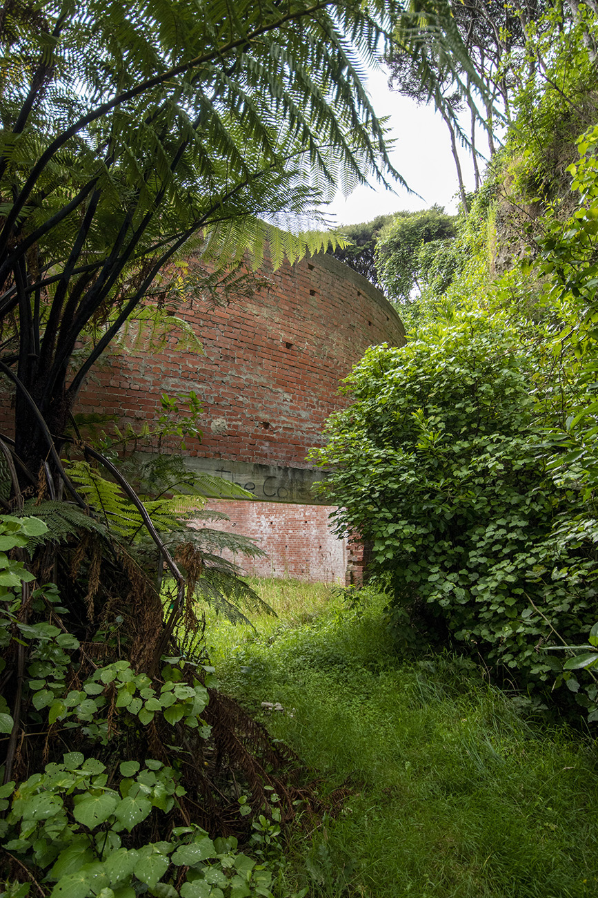
Aesthetic Significance or Value The Fuel Tank Blast Wall at Paekākāriki has aesthetic values as an industrial 'ruin' hidden in a bush-clad environment. The now-quiet location contrasts with its history, the structure evocative of a busy past when Paekākāriki was temporarily transformed by the thousands of US Marines stationed there. The purely functional design has taken on an awe-inspiring quality due to its scale and setting, and ability to be appreciated from within the structure. The high walls holding back the hills and trees but open to the sky, combined with the unusual acoustics of the large circular space, create a slightly surreal environment. Architectural Significance or Value The structure has architectural significance as a reflection of the methods and materials employed by the Public Works Department and Love Construction Co. to quickly meet the requirements of the New Zealand-United States defence network in 1942. It is representative of the string of Aviation Reserves across the country, with 15 sharing the PWD’s design for the splinter-proof brick wall protecting the fuel tanks. Comparison between the three surviving known blast walls (Paekākāriki, Bankside and Ormond) shows the Paekākāriki structure is intact and in good condition, a testament to Love Construction Co’s skills. Social Significance or Value The Brick Fuel Containment Structure has social significance as a valued part of the Kapiti community's heritage, as demonstrated by its conservation requirement in the Transmission Gully motorway consent, protection in the District Plan heritage schedule and feature in exhibitions at the Paekākāriki Station Museum and Kapiti US Marines Trust website. The district’s ongoing connection to its World War Two history is regularly demonstrated by commemorative events and development of interpretation signage and memorials.
Why is this place Category 1 / Category 2?
Detail Of Assessed Criteria
This place was assessed against the Section 66(3) criteria and found to qualify under the following criteria: a, b, d, e, f, g, j, k. The assessment concludes that this place should be listed as a Category 1 historic place. (a) The extent to which the place reflects important or representative aspects of New Zealand history The impact of World War Two reverberated throughout New Zealand and continues to be a major event in New Zealand history. The Fuel Tank Blast Wall has special significance as a direct reflection of the major effort of co-operation between the United States and New Zealand during the Pacific War. Its construction was prioritised in a top-secret programme to boost fuel reserves. The cancellation of its construction before completion reflects the turning points in the Pacific War as Japanese aggression was countered. The Fuel Tank Blast Wall is a rare surviving structure to represent the transformation of New Zealand localities such as Kapiti when they accommodated the US Marines and defence activity. (b) The association of the place with events, persons, or ideas of importance in New Zealand history The Fuel Tank Blast Wall has significance as a demonstration of the value New Zealand places on its role in the global community. It is a physical testament to a time of international collaboration and co-operation under the highest stakes. The World War Two Fuel Tank Blast Wall has value for its association with the Public Works Department who employed a major effort to meet the terms of the United States-New Zealand Mutual Aid Agreement, and the Love Construction Co. Both construction agencies have contributed considerably to New Zealand’s built heritage landscape. (d) The importance of the place to tangata whenua The structure is within the important ancestral landscape of Wainui, significant to mana whenua iwi Ngāti Toa Rangatira and Ngāti Haumia ki Paekākāriki hapū, with shared interests extending to Ātiawa Ki Whakarongotai. The World War Two Fuel Tank Blast Wall is located in the foothills of the ancestral maunga Wainui and Pouawha, and in the valley that was the route taken by Te Rangihaeata when he led his people to safety in 1846 – the gifting of the name Te Ara Nui o Te Rangihaeata demonstrates the great significance of the place to Ngāti Toa Rangatira. The Fuel Tank Wall is also located in an area used for cultivations prior to the land being taken by the Crown, and in the valley of Te Puka Stream which is a tributary to the Wainui Stream. The awa is culturally significant for its lifegiving role in protecting and enhancing the mauri of te taiao (the environment), as a habitat for highly valued mahinga kai species of fish, and for supporting the growth of rongoā plants. The landscape is therefore important to the aspirations and rights of ahikā, papakāinga and kaitiakitanga of mana whenua and tangata whenua. (e) The community association with, or public esteem for the place The community’s esteem for Kapiti’s World War Two history, including the Fuel Tank Blast Wall, is strongly demonstrated by the formation of the Kapiti US Marines Trust who are active in their promotion of the area’s heritage features, and the inclusion of the Fuel Tank structure in Paekākāriki Station Museum displays. Kapiti Coast District Council consider the Blast Tank Wall’s significance to be worthy of protection in the district plan, and the structure was identified for conservation by the Board of Inquiry for the Transmission Gully motorway. Veterans of the US Marines and representatives of the US Government regularly attend Memorial Day commemorations and events to demonstrate their ongoing connection to the location and its heritage. (f) The potential of the place for public education The Fuel Tank Blast Wall has potential as a place to educate the public about New Zealand’s collaboration with the United States in World War Two to counter Japanese aggression in the Pacific. The construction of secret defences such as this is a little-known aspect of the war effort. Although not currently accessible to the public, if safe access was secured following the resolution of the Transmission Gully project the site is highly able to be appreciated and used by the public for recreation and education, especially if in conjunction with the former Perkins Farm buildings. The Fuel Tank is a natural candidate for addition to the network of heritage trails and interpretation signage in the nearby Queen Elizabeth and Whareroa Farm parks. (g) The technical accomplishment, value, or design of the place The Fuel Tank Blast wall remains authentic to its original design and construction, with high integrity as an intact, representative example of its type. It retains its original form, scale and materials, including remnants of the fuel pipeline, valves and sumps, and has been little, if at all, modified since construction was halted. The good condition of the brick wall, which has no obvious signs of cracking despite the pressure from the enclosing hills, demonstrates the quality workmanship. It is considered to be the most authentic surviving example of its type. (j) The importance of identifying rare types of historic places The World War Two Fuel Tank Blast Wall at Paekākāriki has special significance as one of only three confirmed surviving brick blast walls from the network of former Aviation Reserves in New Zealand, with two others possibly still in existence. Amongst the 17 planned AR installations the Paekākāriki example is unusual in that it appears to be the only one built for holding motor spirits for use by the US Marines at the three large camps nearby, instead of aviation fuel. It is also highly authentic and the only example found that has never been even partially filled in, allowing full appreciation of its scale and construction technique. (k) The extent to which the place forms part of a wider historical and cultural area The Fuel Tank Blast Wall’s heritage values are enhanced by its location within a historical landscape containing Kapiti’s only other remaining US Marines building - the Rail Air Goods Shed at Paekākāriki Railway Station - and the network of heritage trails, interpretation and memorials at the adjacent former campsites, now publicly accessible in Queen Elizabeth Park and Whareroa Farm Park. These assist with understanding and appreciation of the former Aviation Reserve (AR17) structure. Summary of Significance or Values The Fuel Tank Blast Wall has outstanding heritage significance as a rare surviving structure representing the transformation of New Zealand localities such as Kapiti when they accommodated the US Marines and defence activity. It has special historical significance as a direct demonstration of New Zealand’s collaboration with the United States to defend the Pacific from Japanese military aggression. As one of only three confirmed surviving blast walls its physical values show the skill and co-operation of the builders in meeting the defence demands of this top-secret programme in a short timeframe. It sits within the important ancestral landscape of Wainui, significant to mana whenua Ngāti Haumia ki Paekākāriki, and also to Ātiawa ki Whakarongotai. Its heritage values are enhanced by its location amidst a historical landscape of the former Kapiti camps and their infrastructure, and the ongoing commemorative activities of the community are evidence of its social esteem.
Why is this place significant?
Cultural Significance
Cultural Significance or Value The structure is located in a landscape of cultural and historical importance to Māori, being situated on the lower slopes of Wainui maunga beside Te Puka Stream, amidst a landscape of former pā, kāinga, mahinga kai, tracks, urupā, tauranga waka and recorded archaeological pit and midden sites that are the ancestral tapuwae (footprints) of the tangata whenua. Te Puka Stream and Wainui remain important to mana whenua kaitiaki Ngāti Haumia ki Paekākāriki of Ngāti Toa, and also to Ātiawa ki Whakarongotai.
Historic Significance
Historical Significance or Value The structure has historical values as a surviving remnant of the mutual aid agreement between New Zealand and the United States in World War Two, which resulted in the small seaside of village of Paekākāriki being touched by the international theatre of war as it hosted three large camps for 15,000 US Marines. Constructed by the Public Works Department as part of a network of enhanced military infrastructure, the structure demonstrates New Zealand's response to the threat of Japanese invasion.
Physical Significance
Aesthetic Significance or Value The Fuel Tank Blast Wall at Paekākāriki has aesthetic values as an industrial 'ruin' hidden in a bush-clad environment. The now-quiet location contrasts with its history, the structure evocative of a busy past when Paekākāriki was temporarily transformed by the thousands of US Marines stationed there. The purely functional design has taken on an awe-inspiring quality due to its scale and setting, and ability to be appreciated from within the structure. The high walls holding back the hills and trees but open to the sky, combined with the unusual acoustics of the large circular space, create a slightly surreal environment. Architectural Significance or Value The structure has architectural significance as a reflection of the methods and materials employed by the Public Works Department and Love Construction Co. to quickly meet the requirements of the New Zealand-United States defence network in 1942. It is representative of the string of Aviation Reserves across the country, with 15 sharing the PWD’s design for the splinter-proof brick wall protecting the fuel tanks. Comparison between the three surviving known blast walls (Paekākāriki, Bankside and Ormond) shows the Paekākāriki structure is intact and in good condition, a testament to Love Construction Co’s skills. Social Significance or Value The Brick Fuel Containment Structure has social significance as a valued part of the Kapiti community's heritage, as demonstrated by its conservation requirement in the Transmission Gully motorway consent, protection in the District Plan heritage schedule and feature in exhibitions at the Paekākāriki Station Museum and Kapiti US Marines Trust website. The district’s ongoing connection to its World War Two history is regularly demonstrated by commemorative events and development of interpretation signage and memorials.
Why is this place Category 1 / Category 2?
Detail Of Assessed Criteria
This place was assessed against the Section 66(3) criteria and found to qualify under the following criteria: a, b, d, e, f, g, j, k. The assessment concludes that this place should be listed as a Category 1 historic place. (a) The extent to which the place reflects important or representative aspects of New Zealand history The impact of World War Two reverberated throughout New Zealand and continues to be a major event in New Zealand history. The Fuel Tank Blast Wall has special significance as a direct reflection of the major effort of co-operation between the United States and New Zealand during the Pacific War. Its construction was prioritised in a top-secret programme to boost fuel reserves. The cancellation of its construction before completion reflects the turning points in the Pacific War as Japanese aggression was countered. The Fuel Tank Blast Wall is a rare surviving structure to represent the transformation of New Zealand localities such as Kapiti when they accommodated the US Marines and defence activity. (b) The association of the place with events, persons, or ideas of importance in New Zealand history The Fuel Tank Blast Wall has significance as a demonstration of the value New Zealand places on its role in the global community. It is a physical testament to a time of international collaboration and co-operation under the highest stakes. The World War Two Fuel Tank Blast Wall has value for its association with the Public Works Department who employed a major effort to meet the terms of the United States-New Zealand Mutual Aid Agreement, and the Love Construction Co. Both construction agencies have contributed considerably to New Zealand’s built heritage landscape. (d) The importance of the place to tangata whenua The structure is within the important ancestral landscape of Wainui, significant to mana whenua iwi Ngāti Toa Rangatira and Ngāti Haumia ki Paekākāriki hapū, with shared interests extending to Ātiawa Ki Whakarongotai. The World War Two Fuel Tank Blast Wall is located in the foothills of the ancestral maunga Wainui and Pouawha, and in the valley that was the route taken by Te Rangihaeata when he led his people to safety in 1846 – the gifting of the name Te Ara Nui o Te Rangihaeata demonstrates the great significance of the place to Ngāti Toa Rangatira. The Fuel Tank Wall is also located in an area used for cultivations prior to the land being taken by the Crown, and in the valley of Te Puka Stream which is a tributary to the Wainui Stream. The awa is culturally significant for its lifegiving role in protecting and enhancing the mauri of te taiao (the environment), as a habitat for highly valued mahinga kai species of fish, and for supporting the growth of rongoā plants. The landscape is therefore important to the aspirations and rights of ahikā, papakāinga and kaitiakitanga of mana whenua and tangata whenua. (e) The community association with, or public esteem for the place The community’s esteem for Kapiti’s World War Two history, including the Fuel Tank Blast Wall, is strongly demonstrated by the formation of the Kapiti US Marines Trust who are active in their promotion of the area’s heritage features, and the inclusion of the Fuel Tank structure in Paekākāriki Station Museum displays. Kapiti Coast District Council consider the Blast Tank Wall’s significance to be worthy of protection in the district plan, and the structure was identified for conservation by the Board of Inquiry for the Transmission Gully motorway. Veterans of the US Marines and representatives of the US Government regularly attend Memorial Day commemorations and events to demonstrate their ongoing connection to the location and its heritage. (f) The potential of the place for public education The Fuel Tank Blast Wall has potential as a place to educate the public about New Zealand’s collaboration with the United States in World War Two to counter Japanese aggression in the Pacific. The construction of secret defences such as this is a little-known aspect of the war effort. Although not currently accessible to the public, if safe access was secured following the resolution of the Transmission Gully project the site is highly able to be appreciated and used by the public for recreation and education, especially if in conjunction with the former Perkins Farm buildings. The Fuel Tank is a natural candidate for addition to the network of heritage trails and interpretation signage in the nearby Queen Elizabeth and Whareroa Farm parks. (g) The technical accomplishment, value, or design of the place The Fuel Tank Blast wall remains authentic to its original design and construction, with high integrity as an intact, representative example of its type. It retains its original form, scale and materials, including remnants of the fuel pipeline, valves and sumps, and has been little, if at all, modified since construction was halted. The good condition of the brick wall, which has no obvious signs of cracking despite the pressure from the enclosing hills, demonstrates the quality workmanship. It is considered to be the most authentic surviving example of its type. (j) The importance of identifying rare types of historic places The World War Two Fuel Tank Blast Wall at Paekākāriki has special significance as one of only three confirmed surviving brick blast walls from the network of former Aviation Reserves in New Zealand, with two others possibly still in existence. Amongst the 17 planned AR installations the Paekākāriki example is unusual in that it appears to be the only one built for holding motor spirits for use by the US Marines at the three large camps nearby, instead of aviation fuel. It is also highly authentic and the only example found that has never been even partially filled in, allowing full appreciation of its scale and construction technique. (k) The extent to which the place forms part of a wider historical and cultural area The Fuel Tank Blast Wall’s heritage values are enhanced by its location within a historical landscape containing Kapiti’s only other remaining US Marines building - the Rail Air Goods Shed at Paekākāriki Railway Station - and the network of heritage trails, interpretation and memorials at the adjacent former campsites, now publicly accessible in Queen Elizabeth Park and Whareroa Farm Park. These assist with understanding and appreciation of the former Aviation Reserve (AR17) structure. Summary of Significance or Values The Fuel Tank Blast Wall has outstanding heritage significance as a rare surviving structure representing the transformation of New Zealand localities such as Kapiti when they accommodated the US Marines and defence activity. It has special historical significance as a direct demonstration of New Zealand’s collaboration with the United States to defend the Pacific from Japanese military aggression. As one of only three confirmed surviving blast walls its physical values show the skill and co-operation of the builders in meeting the defence demands of this top-secret programme in a short timeframe. It sits within the important ancestral landscape of Wainui, significant to mana whenua Ngāti Haumia ki Paekākāriki, and also to Ātiawa ki Whakarongotai. Its heritage values are enhanced by its location amidst a historical landscape of the former Kapiti camps and their infrastructure, and the ongoing commemorative activities of the community are evidence of its social esteem.
Construction Professional
Name
Public Works Department
Type
Builder
Biography
No biography is currently available for this construction professional
Construction Details
Start Year
1942
Finish Year
1943
Type
Original Construction
Description
Excavation of fuel tank site began July 1942, completed October 1942; foundations for blast wall completed January 1943 and bricklaying completed end of February 1943; pipeline excavated, welded and laid between February and April 1943. Construction halted 29 April 1943.
Construction Materials
Brick wall; reinforced concrete foundations, slab base and ring beam; concrete sumps and connecting pipe; steel fuel pipeline and valves.
Notable Features
Earth walls Concrete foundations, pipes, lintels Brick circular walls Pipe work into stream US Marines Truck road and turnaround. Mature trees by 1940s used to camoflague site Site has not be formally surveyed
The climate and resources of the Kapiti Coast have attracted people for many centuries. Traditions hold that Kapiti Island was sliced from the mainland by the great Polynesian explorer Kupe. Following permanent settlement in Aotearoa, the rangatira Tara, son of Whātonga of the Kurahaupō waka, settled at what came to be known as Te Whanganui-a-Tara (Wellington harbour) and around the region. Descendants of his brother Tautoki, known as Rangitāne, settled in Kapiti, the Manawatū and Wairarapa. In time, groups now known as Muaūpoko and Ngāti Apa also emerged and settled in the district, and were closely allied with their Rangitāne kin. Ngāti Rangi hapū are said to have occupied the area around Paekākāriki and Paraparaumu. In the seventeenth century Ngāti Ira of Hawke’s Bay arrived in the region and extensive intermarriage occurred. Other iwi who made a home in the region included Ngāti Kahungunu, Ngāi Tahu, and Ngāti Māmoe. Nineteenth century arrivals in the district From 1819, war parties (taua) and successive migrations (heke) of northern tribes triggered more conflict and dislocation in the region. The catalyst for this has often been attributed to the northern Māori acquisition of European muskets but other factors contributed, such as changing codes of inter-tribal relations, changing practices of warfare, and increased population pressure on traditional resources. A phase of warfare in the Waikato resulted in groups from Kāwhia, including Ngāti Toa Rangatira and Ngāti Koata, migrating to Kapiti in the early 1820s, after a stay in Taranaki. Ngāti Toa Rangatira descend from Hoturoa through Tuhianga, Mango and Tupahau. Their allies from Taranaki (Ngātiawa/Te Ātiawa, Ngāti Mutunga, Ngāti Maru and Ngāti Tama) followed suit, fearing retaliation from Waikato for having defended Motunui in 1822. Kapiti offered a strategic location and valuable access to trading with the Pākehā whalers who were beginning to frequent Raukawa Moana (Cook Strait). Tikanga Māori traditionally established resource rights through raupatu (conquest). Conflicts between Ngāti Toa and Muaūpoko at Papaitonga resulted in Muāupoko dispersing to refuge pā, including the escarpment at Paekākāriki. The migrants’ claim of Kapiti was strengthened after the battle of Waiorua in 1824, in which a large force of established tangata whenua failed to oust the newcomers from Kapiti and Te Tau Ihu. After this, Muaūpoko, Ngāti Apa and Rangitāne withdrew northwards and Ngāti Ira south. Ngāti Toa settled the district and were soon joined by major heke of hapū and whanau from Taranaki. Ngāti Raukawa, a Tainui tribe from the Waikato with kinship links to prominent Ngāti Toa chief Te Rauparaha’s family, migrated to the northern Kapiti coast in the late 1820s. Kapiti’s population was further boosted in the early 1830s with more large migrations from Taranaki. Tensions in the increasingly crowded district built to a head in 1834 at Haowhenua pā, Ōtaki, with significant losses on all sides. Another major inter-tribal conflict known as Te Kuititanga occurred in 1839. Impacts of colonial settlement Christianity began to gain influence among Kapiti Māori in the late 1830s. Negotiations with New Zealand Company agents looking to purchase land for colonial settlement were also a prominent factor in the gradual settling of the nuanced cycles of war and dynamic movements of Māori in the Wellington region, as tribal boundaries were established. In the 1840s, however, colonial competition for land intensified conflict. Māori land at Kapiti was alienated through the Porirua Deed of 1847. The Deed created reserves for Māori settlements and cultivations, including one at Paekākāriki and a village site nearby at the mouth of the Wainui Stream. By this time, tensions over land in the Hutt Valley had resulted in the government detaining Te Rauparaha, and attacking his nephew Te Rangihaeata’s pā at Pāuatahanui after the 1846 battle between Māori and Crown troops at Boulcott’s farm. Te Rangihaeata took position at what became known as Battle Hill, which was heavily shelled by the government force before they discovered that Te Rangihaeata had led his people to safety under cover of darkness. His escape route northwards followed the path of today’s Transmission Gully motorway, now commemorated with the name Te Ara Nui o Te Rangihaeata which Ngāti Toa Rangatira gifted in recognition of the place’s significance. Wainui Block In 1859 the Crown purchased the Wainui Block, 30,000 acres of land which included the previous Ngāti Toa reserves at Wainui and Paekākāriki and created new reserves including Whareroa Pā (an important Te Ātiawa kāinga), and 50 acres of cultivation grounds at Te Puka, very near to the future Fuel Tank site. Ballara records Ngāti Toa hapū Ngāti Te Maunu as living at Wainui Pā, near the mouth of the stream, in the late 1820s. Ngāti Toa chief Ropata Hurumutu (1805-1875) of Ngāti Haumia ki Paekākāriki hapū settled there around 1834 and in 1871 he described it as being a large pā, with some timber houses, a school and a flour mill. In 1850 H. Tacy Kemp observed around 195 people living there, growing wheat and kumara, processing flax, and about to move from older buildings to a new village site nearby, laid out by the government. Cultivations were Ngapaiparua, Rongo-o-Te-Wera (Ramaroa), Te Puka, Wairaka and Paekākāriki. Ngāti Haumia ki Paekākāriki have maintained ahikā at Wainui. Miriona Mutu Mira Budge (d.1970), a descendant of Ropata Hurumutu and another Wainui rangatira Aperamaha Mutu Mira, is an important twentieth-century tupuna of Ngāti Haumia ki Paekākāriki who devoted herself to the Paekākāriki community. In the mid-1830s neighbouring Whareroa Pā and its 13 acres of cultivations were occupied by the Ngāti Maru section of Te Ātiawa under Mitikaukau, who also occupied nearby Tipapa. Te Ātiawa descend from Toi-te-huatahi or To-kai-rakau, who was the grandfather of Awanuiarangi, the eponymous ancestor of the iwi. Te Ātiawa of Taranaki associate their identity with the Tokomaru waka. There are strong interconnections between Ngāti Toa, Ngāti Tama and Te Ātiawa at Wainui and Whareroa. The Wainui Stream, and its tributary Te Puka Stream, are vital to the mauri of the locality. The lifegiving force of this awa enhances and protects the mauri of te taiao (the environment) and its people; the awa is a key indicator of its health. Te Puka and Wainui Stream have historically contained highly valued mahinga kai species of native migratory fish, such as longfin eel, koaro and redfin bully. The awa also supports the growth of rongoā plant species, important for traditional healing practices. Restricted access and the degradation of the stream’s health through Pākehā farming, roading and watercourse management activities impacted tangata whenua’s kaitiaki of the whenua. The 1847 military construction of the Paekakariki Hill Road opened up the land via an inland route along the Horokiri Valley between Pauatahanui and Paekākāriki. Construction of the Wellington-Manawatu Railway line in 1886 increased accessibility, after which the village of Paekākāriki developed. Much of the northern end of Transmission Gully became owned and farmed by the Smith family. Tangata whenua retained a presence in the area and continued to care for their reserves, often leasing them to farmers. Native title for Te Puka Reserve was issued to Aperahama Mira, Ropata and Hirini Tangahoe, Wi Parata Te Kakakura and Heipiri Riki in 1888. By 1916 it had been sold to Leonard Smith. His brother Harold Smith owned the adjacent sheep farm in Transmission Gully, named ‘Middle Run’, which was where the Fuel Tank Wall would be built. Many of the Smith’s shearers were local Māori whanau. World War Two The outbreak of World War Two in 1939 immediately affected New Zealand, including those who left to serve overseas and those on the home front. But the bombing of Pearl Harbour on 7 December 1941 brought the threat of Japanese invasion suddenly closer. New Zealand joined the United States and Britain in declaring war on Japan, and on 12 June 1942 the country began hosting US servicemen in a mutually beneficial arrangement: New Zealand was a strategic staging and supply post for the US Military’s operations in the Pacific, while the Marines strengthened our defences. Between June 1942 and mid-1944, 15,000-45,000 US Marines were at any one time stationed in various camps and facilities in the North Island. American servicemen received training for upcoming offensives, or rest and recovery in the aftermath of deployment. Facilities were a mix of temporary, purpose-built, and re-purposed existing buildings, prepared with the assistance of the Public Works Department (PWD) under the terms of the United States-New Zealand Mutual Aid Agreement signed in early 1942. Over 50 accommodation camps were set up. Paekākāriki was the location for three large camps, housing up to 15,000 men of the 1st and 2nd Marine Divisions of the US Marines Corps, and transforming the village of 530 residents. Construction of Camp Paekakariki began on what is now the northern half of the village on 19 May 1942. Camp McKay was built nearby on former Ramaroa Reserve land, and the ‘Rail Air Shed’, a large goods depot for the camps, was built at the Paekākāriki Railway Station. On 14 June the first US troops arrived at the Paekākāriki camps for six weeks of training, before departing to Guadalcanal. On 4 November 1942 the next groups arrived for a training block. The Paekākāriki camps were expanded in February 1943 with the construction of Camp Russell (in what became Queen Elizabeth Park) to accommodate a large number of returning troops for an extended period of rest and recovery from the gruelling Pacific campaigns. Author Leon Uris published the novel Battle Cry about his time as a Marine at the Paekākāriki camps. Paekākāriki seemed to the Marines like ‘heaven after hell’, and the locals opened their homes and hearts to the troops. Ngāti Haumia ki Paekākāriki provided much manaakitanga for the soldiers, despite the damage the camps were doing to their whenua. Jean Andrews, daughter of Miriona Budge, recalled letting 30 soldiers use her kitchen on their first night in the camp, their regular use of her laundry, and her enjoyment of the dances, shows and movies at St Peter’s Hall. She also recalled suffering from the racist attitudes of some of the Americans. Ngāti Haumia ki Paekākāriki assisted with the recovery of the bodies of Marines who drowned in a tragic beach-landing training exercise on 20 June 1943. Aviation Fuel Reserves: the Paekākāriki Fuel Tank Blast Wall In March 1942 the New Zealand government realised the need for increased storage of aviation fuel, as the US Military planned to station up to 200 aircraft here at bomber bases. 12 fuel depot installations were initially planned, but Paekākāriki was not on the first list of priority sites as it hadn’t yet been chosen as a camp location. However, the construction of what would become Aviation Reserve (AR) 17 at Paekākāriki was ordered in May 1942, after a committee from the Public Works Department, Air Force, Army Camouflage Unit, Railways Department, and Air Secretary’s office had selected the tank’s location. A pre-fabricated 350,000 gallon tank of bolted panels was shipped from the US due to local steel shortages, to be erected in an excavated nook of the Te Puka stream gully that could be covered with camouflage netting (a Japanese reconnaissance plane had been seen over Wellington in March 1942). A steel pipeline would run the fuel to a siding on the railway line opposite the site. Road filling points were also included in the design, disguised at a turning circle laid out ‘in an irregular manner…to give the appearance of an access track to serve the various farm buildings.’ The site was adjacent to the transport depot that served the camps, all of which were within easy walking distance. Although urgent, construction of the fuel depot was delayed for a month due to the unavailability of mechanical excavators. Works began in mid-July 1942, but the PWD reported that progress was slow due to the difficult site and waterlogged clay soil. In September 1942, brick walls were added to the designs for all of the AR depots that were receiving bolted tanks. The surrounding ‘splinter-proof’ or ‘blast walls’ would protect the tanks from pressure or piercing from a near-miss from a bomb, and at Paekākāriki, help retain the earth. A gap between the tank and wall would allow for tightening of the tank joints and other maintenance. Love Construction Co., a major national construction firm and predecessor of today’s Naylor Love, was contracted to build the brick blast wall in January 1943 once the PWD had completed the foundations, and they had finished building the wall by mid-March. It included an access cut at ground level to allow the wall to be breached and the tank emptied into the stream in case of emergency. The construction of the fuel pipeline and the preparation of the tank was happening at the same time. The pipeline required excavation of a 2200-foot (670 metre) trench roughly following the farm access track beside the stream. The welding and joining of the 4-inch steel pipe, which was then sheathed in protective asphalt coating, was done by engineers of the US Marine Corps. The second-hand tank panels, which had arrived from America on the Philae on 30 July 1942, were in such poor condition that they had to be sandblasted and painted before assembly could be considered. Preparation of the panels began in February 1943 but plant trouble meant progress was slow, and by late April only the tank’s base panels were ready to be assembled. However, before assembly could begin, all work on AR17 at Paekākāriki was stopped. A change of strategy While the first six months of the Pacific War had caused great concern for Pacific nations as Japan occupied Hong Kong, Singapore and the Philippines, and air-raided Indonesia and Darwin, the US Victory at the Battle of Midway in June 1942 effectively ended the danger of invasion in New Zealand. Subsequent US campaigns at Guadalcanal and Papua further turned the tide. At the end of December 1942 Washington ordered the Aviation Reserve programme in New Zealand be scaled back, with construction of AR5 (Greatford) and AR8 (Wiri) stopped. The order notes that the Paekākāriki installation was, at that stage, to continue, despite it being behind schedule. From February to November 1943 the largest number of US Marines were in residence at the Paekākāriki camps for an extended period of recuperation, and it may have been this factor that allowed the USMC Engineers to speed up progress with their work on the fuel pipeline. However, by April 1943 the US-New Zealand allied strategists had decided that the need for fuel reserves had diminished to the point where any installations not yet completed would be cancelled. At Paekākāriki, the railway siding had been built; the tank slab base and blast wall were complete but earth battering and backfilling around it was not; the pipeline was laid but not hooked up to the tank; and the tank panels were still being prepared so none had yet been laid or assembled. Orders were therefore given to remove all works including the railway siding, fill in the excavation and return the fuel tank site to its original condition. Sandblasting of the tank panels was the only aspect of the project to be continued before they were packed up and sent to RNZAF Mangaroa, as they would otherwise deteriorate. The US Marines permanently vacated the Paekākāriki Camps, and left New Zealand, on 1 November 1943 when they were deployed to Tarawa Atoll in Kiribati. The War Assets Realization Board was set up to dispose of surplus buildings and equipment, to ensure redeployment of scarce assets. The camps were dismantled (and 569 of the buildings at Paekākāriki sold for disposal) and the land cleared, ostensibly for return to the people who had owned it before it was seized. However, Public Works Department officials protested against destroying the tank wall and pipeline, pointing out the considerable money spent on the project, and, as the pipeline had never been used for fuel, the suitability of the site for use as a water reservoir. This use was duly explored, and the Hutt County Council then the Railways Department were approached about taking it over. However, the Council had recently secured an alternative water supply on Leonard Smith’s neighbouring farm, and the fuel tank site in the Te Puka Stream gully wasn’t conveniently close enough to Paekākāriki Railway Station, so both declined. By 1947 the economics of leaving the installation in situ versus removing it had become clear, and its presence was no doubt added to the list of compensation paid to Harold Smith for wartime use of his land. After the end of the Second World War in 1945, the Government determined to use most of the land it had taken at Paekākāriki for other purposes. The Smiths were pressured to sell more than 500 acres of the former camp sites. They held onto their Transmission Gully ‘Middle Run’ farmland and it became known as ‘Perkins Farm’ after Harold Smith’s daughter Betty and son-in-law John Perkins took it over in 1970. The former Māori land of the Wainui Reserve was not returned to its original owners, despite Miriona Budge fighting hard for it. Much of Wainui Reserve was developed for residential growth of Paekākāriki, and new streets were named in memory of both the US Marines and the ancestry of Ngāti Haumia ki Paekākāriki. In 1953 the farmland north of the main road was permanently acquired by the Crown for the creation of Queen Elizabeth Park, a 1627-acre recreation reserve stretching between Paekākāriki and Raumati South. The adjacent Whareroa Farm Park was also created on former Ramaroa Reserve land. John and Betty Perkins continued to farm Middle Run until 2012, when after decades of negotiations the Crown agreed to acquire the entire property for the Transmission Gully motorway, a project that had been mooted for many years. The Fuel Tank Wall was identified as a heritage site that could be affected by the works as it was within the road designation. Conservation of the Fuel Tank Wall was made a condition of the consent. The US Marines remain important in the history of Paekākāriki and Queen Elizabeth Park, with history books and exhibits continuing to educate people about the time when the district played such a part in the ‘friendly invasion’. Memorial gates were installed at Queen Elizabeth Park in 1962 as a physical marker of the camps, and have since been supplemented by prominent signage and memorials throughout the park and at Whareroa Park. In 2009 the Kapiti US Marines Trust was formed to mark, research and celebrate the US Marines presence in the district. Their informative website shows the connections maintained with many veterans and the US Embassy, who attend annual services of commemoration on Memorial Day. A major event was held for the 70th anniversary in 2012.
The climate and resources of the Kapiti Coast have attracted people for many centuries. Traditions hold that Kapiti Island was sliced from the mainland by the great Polynesian explorer Kupe. Following permanent settlement in Aotearoa, the rangatira Tara, son of Whātonga of the Kurahaupō waka, settled at what came to be known as Te Whanganui-a-Tara (Wellington harbour) and around the region. Descendants of his brother Tautoki, known as Rangitāne, settled in Kapiti, the Manawatū and Wairarapa. In time, groups now known as Muaūpoko and Ngāti Apa also emerged and settled in the district, and were closely allied with their Rangitāne kin. Ngāti Rangi hapū are said to have occupied the area around Paekākāriki and Paraparaumu. In the seventeenth century Ngāti Ira of Hawke’s Bay arrived in the region and extensive intermarriage occurred. Other iwi who made a home in the region included Ngāti Kahungunu, Ngāi Tahu, and Ngāti Māmoe. Nineteenth century arrivals in the district From 1819, war parties (taua) and successive migrations (heke) of northern tribes triggered more conflict and dislocation in the region. The catalyst for this has often been attributed to the northern Māori acquisition of European muskets but other factors contributed, such as changing codes of inter-tribal relations, changing practices of warfare, and increased population pressure on traditional resources. A phase of warfare in the Waikato resulted in groups from Kāwhia, including Ngāti Toa Rangatira and Ngāti Koata, migrating to Kapiti in the early 1820s, after a stay in Taranaki. Ngāti Toa Rangatira descend from Hoturoa through Tuhianga, Mango and Tupahau. Their allies from Taranaki (Ngātiawa/Te Ātiawa, Ngāti Mutunga, Ngāti Maru and Ngāti Tama) followed suit, fearing retaliation from Waikato for having defended Motunui in 1822. Kapiti offered a strategic location and valuable access to trading with the Pākehā whalers who were beginning to frequent Raukawa Moana (Cook Strait). Tikanga Māori traditionally established resource rights through raupatu (conquest). Conflicts between Ngāti Toa and Muaūpoko at Papaitonga resulted in Muāupoko dispersing to refuge pā, including the escarpment at Paekākāriki. The migrants’ claim of Kapiti was strengthened after the battle of Waiorua in 1824, in which a large force of established tangata whenua failed to oust the newcomers from Kapiti and Te Tau Ihu. After this, Muaūpoko, Ngāti Apa and Rangitāne withdrew northwards and Ngāti Ira south. Ngāti Toa settled the district and were soon joined by major heke of hapū and whanau from Taranaki. Ngāti Raukawa, a Tainui tribe from the Waikato with kinship links to prominent Ngāti Toa chief Te Rauparaha’s family, migrated to the northern Kapiti coast in the late 1820s. Kapiti’s population was further boosted in the early 1830s with more large migrations from Taranaki. Tensions in the increasingly crowded district built to a head in 1834 at Haowhenua pā, Ōtaki, with significant losses on all sides. Another major inter-tribal conflict known as Te Kuititanga occurred in 1839. Impacts of colonial settlement Christianity began to gain influence among Kapiti Māori in the late 1830s. Negotiations with New Zealand Company agents looking to purchase land for colonial settlement were also a prominent factor in the gradual settling of the nuanced cycles of war and dynamic movements of Māori in the Wellington region, as tribal boundaries were established. In the 1840s, however, colonial competition for land intensified conflict. Māori land at Kapiti was alienated through the Porirua Deed of 1847. The Deed created reserves for Māori settlements and cultivations, including one at Paekākāriki and a village site nearby at the mouth of the Wainui Stream. By this time, tensions over land in the Hutt Valley had resulted in the government detaining Te Rauparaha, and attacking his nephew Te Rangihaeata’s pā at Pāuatahanui after the 1846 battle between Māori and Crown troops at Boulcott’s farm. Te Rangihaeata took position at what became known as Battle Hill, which was heavily shelled by the government force before they discovered that Te Rangihaeata had led his people to safety under cover of darkness. His escape route northwards followed the path of today’s Transmission Gully motorway, now commemorated with the name Te Ara Nui o Te Rangihaeata which Ngāti Toa Rangatira gifted in recognition of the place’s significance. Wainui Block In 1859 the Crown purchased the Wainui Block, 30,000 acres of land which included the previous Ngāti Toa reserves at Wainui and Paekākāriki and created new reserves including Whareroa Pā (an important Te Ātiawa kāinga), and 50 acres of cultivation grounds at Te Puka, very near to the future Fuel Tank site. Ballara records Ngāti Toa hapū Ngāti Te Maunu as living at Wainui Pā, near the mouth of the stream, in the late 1820s. Ngāti Toa chief Ropata Hurumutu (1805-1875) of Ngāti Haumia ki Paekākāriki hapū settled there around 1834 and in 1871 he described it as being a large pā, with some timber houses, a school and a flour mill. In 1850 H. Tacy Kemp observed around 195 people living there, growing wheat and kumara, processing flax, and about to move from older buildings to a new village site nearby, laid out by the government. Cultivations were Ngapaiparua, Rongo-o-Te-Wera (Ramaroa), Te Puka, Wairaka and Paekākāriki. Ngāti Haumia ki Paekākāriki have maintained ahikā at Wainui. Miriona Mutu Mira Budge (d.1970), a descendant of Ropata Hurumutu and another Wainui rangatira Aperamaha Mutu Mira, is an important twentieth-century tupuna of Ngāti Haumia ki Paekākāriki who devoted herself to the Paekākāriki community. In the mid-1830s neighbouring Whareroa Pā and its 13 acres of cultivations were occupied by the Ngāti Maru section of Te Ātiawa under Mitikaukau, who also occupied nearby Tipapa. Te Ātiawa descend from Toi-te-huatahi or To-kai-rakau, who was the grandfather of Awanuiarangi, the eponymous ancestor of the iwi. Te Ātiawa of Taranaki associate their identity with the Tokomaru waka. There are strong interconnections between Ngāti Toa, Ngāti Tama and Te Ātiawa at Wainui and Whareroa. The Wainui Stream, and its tributary Te Puka Stream, are vital to the mauri of the locality. The lifegiving force of this awa enhances and protects the mauri of te taiao (the environment) and its people; the awa is a key indicator of its health. Te Puka and Wainui Stream have historically contained highly valued mahinga kai species of native migratory fish, such as longfin eel, koaro and redfin bully. The awa also supports the growth of rongoā plant species, important for traditional healing practices. Restricted access and the degradation of the stream’s health through Pākehā farming, roading and watercourse management activities impacted tangata whenua’s kaitiaki of the whenua. The 1847 military construction of the Paekakariki Hill Road opened up the land via an inland route along the Horokiri Valley between Pauatahanui and Paekākāriki. Construction of the Wellington-Manawatu Railway line in 1886 increased accessibility, after which the village of Paekākāriki developed. Much of the northern end of Transmission Gully became owned and farmed by the Smith family. Tangata whenua retained a presence in the area and continued to care for their reserves, often leasing them to farmers. Native title for Te Puka Reserve was issued to Aperahama Mira, Ropata and Hirini Tangahoe, Wi Parata Te Kakakura and Heipiri Riki in 1888. By 1916 it had been sold to Leonard Smith. His brother Harold Smith owned the adjacent sheep farm in Transmission Gully, named ‘Middle Run’, which was where the Fuel Tank Wall would be built. Many of the Smith’s shearers were local Māori whanau. World War Two The outbreak of World War Two in 1939 immediately affected New Zealand, including those who left to serve overseas and those on the home front. But the bombing of Pearl Harbour on 7 December 1941 brought the threat of Japanese invasion suddenly closer. New Zealand joined the United States and Britain in declaring war on Japan, and on 12 June 1942 the country began hosting US servicemen in a mutually beneficial arrangement: New Zealand was a strategic staging and supply post for the US Military’s operations in the Pacific, while the Marines strengthened our defences. Between June 1942 and mid-1944, 15,000-45,000 US Marines were at any one time stationed in various camps and facilities in the North Island. American servicemen received training for upcoming offensives, or rest and recovery in the aftermath of deployment. Facilities were a mix of temporary, purpose-built, and re-purposed existing buildings, prepared with the assistance of the Public Works Department (PWD) under the terms of the United States-New Zealand Mutual Aid Agreement signed in early 1942. Over 50 accommodation camps were set up. Paekākāriki was the location for three large camps, housing up to 15,000 men of the 1st and 2nd Marine Divisions of the US Marines Corps, and transforming the village of 530 residents. Construction of Camp Paekakariki began on what is now the northern half of the village on 19 May 1942. Camp McKay was built nearby on former Ramaroa Reserve land, and the ‘Rail Air Shed’, a large goods depot for the camps, was built at the Paekākāriki Railway Station. On 14 June the first US troops arrived at the Paekākāriki camps for six weeks of training, before departing to Guadalcanal. On 4 November 1942 the next groups arrived for a training block. The Paekākāriki camps were expanded in February 1943 with the construction of Camp Russell (in what became Queen Elizabeth Park) to accommodate a large number of returning troops for an extended period of rest and recovery from the gruelling Pacific campaigns. Author Leon Uris published the novel Battle Cry about his time as a Marine at the Paekākāriki camps. Paekākāriki seemed to the Marines like ‘heaven after hell’, and the locals opened their homes and hearts to the troops. Ngāti Haumia ki Paekākāriki provided much manaakitanga for the soldiers, despite the damage the camps were doing to their whenua. Jean Andrews, daughter of Miriona Budge, recalled letting 30 soldiers use her kitchen on their first night in the camp, their regular use of her laundry, and her enjoyment of the dances, shows and movies at St Peter’s Hall. She also recalled suffering from the racist attitudes of some of the Americans. Ngāti Haumia ki Paekākāriki assisted with the recovery of the bodies of Marines who drowned in a tragic beach-landing training exercise on 20 June 1943. Aviation Fuel Reserves: the Paekākāriki Fuel Tank Blast Wall In March 1942 the New Zealand government realised the need for increased storage of aviation fuel, as the US Military planned to station up to 200 aircraft here at bomber bases. 12 fuel depot installations were initially planned, but Paekākāriki was not on the first list of priority sites as it hadn’t yet been chosen as a camp location. However, the construction of what would become Aviation Reserve (AR) 17 at Paekākāriki was ordered in May 1942, after a committee from the Public Works Department, Air Force, Army Camouflage Unit, Railways Department, and Air Secretary’s office had selected the tank’s location. A pre-fabricated 350,000 gallon tank of bolted panels was shipped from the US due to local steel shortages, to be erected in an excavated nook of the Te Puka stream gully that could be covered with camouflage netting (a Japanese reconnaissance plane had been seen over Wellington in March 1942). A steel pipeline would run the fuel to a siding on the railway line opposite the site. Road filling points were also included in the design, disguised at a turning circle laid out ‘in an irregular manner…to give the appearance of an access track to serve the various farm buildings.’ The site was adjacent to the transport depot that served the camps, all of which were within easy walking distance. Although urgent, construction of the fuel depot was delayed for a month due to the unavailability of mechanical excavators. Works began in mid-July 1942, but the PWD reported that progress was slow due to the difficult site and waterlogged clay soil. In September 1942, brick walls were added to the designs for all of the AR depots that were receiving bolted tanks. The surrounding ‘splinter-proof’ or ‘blast walls’ would protect the tanks from pressure or piercing from a near-miss from a bomb, and at Paekākāriki, help retain the earth. A gap between the tank and wall would allow for tightening of the tank joints and other maintenance. Love Construction Co., a major national construction firm and predecessor of today’s Naylor Love, was contracted to build the brick blast wall in January 1943 once the PWD had completed the foundations, and they had finished building the wall by mid-March. It included an access cut at ground level to allow the wall to be breached and the tank emptied into the stream in case of emergency. The construction of the fuel pipeline and the preparation of the tank was happening at the same time. The pipeline required excavation of a 2200-foot (670 metre) trench roughly following the farm access track beside the stream. The welding and joining of the 4-inch steel pipe, which was then sheathed in protective asphalt coating, was done by engineers of the US Marine Corps. The second-hand tank panels, which had arrived from America on the Philae on 30 July 1942, were in such poor condition that they had to be sandblasted and painted before assembly could be considered. Preparation of the panels began in February 1943 but plant trouble meant progress was slow, and by late April only the tank’s base panels were ready to be assembled. However, before assembly could begin, all work on AR17 at Paekākāriki was stopped. A change of strategy While the first six months of the Pacific War had caused great concern for Pacific nations as Japan occupied Hong Kong, Singapore and the Philippines, and air-raided Indonesia and Darwin, the US Victory at the Battle of Midway in June 1942 effectively ended the danger of invasion in New Zealand. Subsequent US campaigns at Guadalcanal and Papua further turned the tide. At the end of December 1942 Washington ordered the Aviation Reserve programme in New Zealand be scaled back, with construction of AR5 (Greatford) and AR8 (Wiri) stopped. The order notes that the Paekākāriki installation was, at that stage, to continue, despite it being behind schedule. From February to November 1943 the largest number of US Marines were in residence at the Paekākāriki camps for an extended period of recuperation, and it may have been this factor that allowed the USMC Engineers to speed up progress with their work on the fuel pipeline. However, by April 1943 the US-New Zealand allied strategists had decided that the need for fuel reserves had diminished to the point where any installations not yet completed would be cancelled. At Paekākāriki, the railway siding had been built; the tank slab base and blast wall were complete but earth battering and backfilling around it was not; the pipeline was laid but not hooked up to the tank; and the tank panels were still being prepared so none had yet been laid or assembled. Orders were therefore given to remove all works including the railway siding, fill in the excavation and return the fuel tank site to its original condition. Sandblasting of the tank panels was the only aspect of the project to be continued before they were packed up and sent to RNZAF Mangaroa, as they would otherwise deteriorate. The US Marines permanently vacated the Paekākāriki Camps, and left New Zealand, on 1 November 1943 when they were deployed to Tarawa Atoll in Kiribati. The War Assets Realization Board was set up to dispose of surplus buildings and equipment, to ensure redeployment of scarce assets. The camps were dismantled (and 569 of the buildings at Paekākāriki sold for disposal) and the land cleared, ostensibly for return to the people who had owned it before it was seized. However, Public Works Department officials protested against destroying the tank wall and pipeline, pointing out the considerable money spent on the project, and, as the pipeline had never been used for fuel, the suitability of the site for use as a water reservoir. This use was duly explored, and the Hutt County Council then the Railways Department were approached about taking it over. However, the Council had recently secured an alternative water supply on Leonard Smith’s neighbouring farm, and the fuel tank site in the Te Puka Stream gully wasn’t conveniently close enough to Paekākāriki Railway Station, so both declined. By 1947 the economics of leaving the installation in situ versus removing it had become clear, and its presence was no doubt added to the list of compensation paid to Harold Smith for wartime use of his land. After the end of the Second World War in 1945, the Government determined to use most of the land it had taken at Paekākāriki for other purposes. The Smiths were pressured to sell more than 500 acres of the former camp sites. They held onto their Transmission Gully ‘Middle Run’ farmland and it became known as ‘Perkins Farm’ after Harold Smith’s daughter Betty and son-in-law John Perkins took it over in 1970. The former Māori land of the Wainui Reserve was not returned to its original owners, despite Miriona Budge fighting hard for it. Much of Wainui Reserve was developed for residential growth of Paekākāriki, and new streets were named in memory of both the US Marines and the ancestry of Ngāti Haumia ki Paekākāriki. In 1953 the farmland north of the main road was permanently acquired by the Crown for the creation of Queen Elizabeth Park, a 1627-acre recreation reserve stretching between Paekākāriki and Raumati South. The adjacent Whareroa Farm Park was also created on former Ramaroa Reserve land. John and Betty Perkins continued to farm Middle Run until 2012, when after decades of negotiations the Crown agreed to acquire the entire property for the Transmission Gully motorway, a project that had been mooted for many years. The Fuel Tank Wall was identified as a heritage site that could be affected by the works as it was within the road designation. Conservation of the Fuel Tank Wall was made a condition of the consent. The US Marines remain important in the history of Paekākāriki and Queen Elizabeth Park, with history books and exhibits continuing to educate people about the time when the district played such a part in the ‘friendly invasion’. Memorial gates were installed at Queen Elizabeth Park in 1962 as a physical marker of the camps, and have since been supplemented by prominent signage and memorials throughout the park and at Whareroa Park. In 2009 the Kapiti US Marines Trust was formed to mark, research and celebrate the US Marines presence in the district. Their informative website shows the connections maintained with many veterans and the US Embassy, who attend annual services of commemoration on Memorial Day. A major event was held for the 70th anniversary in 2012.
Current Description Wainui is the ancestral landscape of Ngāti Toa Rangatira at Kapiti. Wainui is the land between Te Ana-a-Hau (just south of Paekākāriki) and Whareroa Stream at the north, and stretches inland to Whakataka Pā at Upper Hutt and the Tararua Range. The World War Two Fuel Tank Blast Wall is nestled in the foothills of the ancestral maunga Wainui and Pouawha, in a landscape of former cultivations, papakāinga, mahinga kai and tauranga waka at the coast, connected with a network of tracks inland . The Te Puka Stream, a tributary to the Wainui Stream, runs alongside the Fuel Tank Wall; this awa remains culturally and historically significant to mana whenua Ngāti Toa Rangatira, with shared interests extending to Ātiawa ki Whakarongotai. The World War Two Fuel Tank Blast Wall is located at the northern end of Te Ara Nui o Te Rangihaeata/Transmission Gully (State Highway 1). The structure is tucked into a former meander of the stream, approximately 20 metres west of the motorway but below the road level. The village of Paekākāriki sits over the ridgeline to the west, the open dunelands of Queen Elizabeth Park (site of Camp Paekakariki and Camp Russell) to the north, and Whareroa Farm Park (site of Camp MacKay) to the northeast. The Fuel Tank Wall is largely obscured by native bush including mature kohekohe, titoki and kanuka and is not visible from any distance. A farm track provides access alongside the stream, and the Fuel Tank Wall sits on a platform elevated approximately 10 metres above the stream bed. On approach through perimeter security fencing, less than one quarter of the brick wall structure is visible. Around three-quarters of the circumference of the wall has been backfilled, and the surrounding bush partially screens the open approach. The structure consists of a 10-metre-high circular brick wall enclosing an open space approximately 18 metres in diameter. The 350,000-gallon (1.3 million litre), 55 foot (16 metre) wide x 24 foot (7.3 metre) high bolted steel tank (never installed) was intended to sit inside leaving a gap between it and the enclosing wall. Access to the interior is gained at ground level through a cut in the brickwork; although this opening is supported by a concrete lintel beam the rough edges of the brickwork above a certain height suggest a slight change in plans during construction. The lintel has been vandalised with modern graffiti painting, although deeply inscribed initials ‘eg ‘D.K.’ may date from earlier when the concrete was softer. The mortar visible on the exterior of the wall is more roughly pointed than that on the interior, aligning with the original plans to completely backfill around the exterior. Strands of reinforcing steel protrude from above the lintel. The scale of the enclosure – although open to the sky – is impressive, as are the acoustics. Native bush fringes the top and towers above the enclosure, but is not oppressive because of the diameter of the open space. The ground is slightly uneven underfoot, the tank base now topped with grass concealing random rubble. The wall sits on a 2-foot-wide x 1-foot-high reinforced concrete foundation, and a 12-inch (30 centimetre) x 9-inch (22 centimetre) reinforced concrete bond beam ties it together at the top. The bricks are laid in common bond. At its base the wall is three bricks deep but just over halfway up this steps in to two bricks deep. Weepholes are dotted at regular intervals, more frequently in the lower section. Original plans show intentions to build a battered earth wall around the open, stream-facing section of the structure so it would be completely surrounded by earth walls. The rungs of a steel ladder fixed to the brickwork of the interior, above the opening in the brickwork, show the means of original access. At the north of the opening, at ground level another small opening surrounded by reinforced concrete is visible. This is the inner drainage sump, connected by a pipe to the outer drainage sump approximately 18 metres west above the edge of the farm track. The outer sump is sunken within an open concrete chamber draining to a concrete pipe. The outer sump also contains a steel pipe and valve for the original fuel pipeline, which was laid for 2200 feet (670 metres) largely following the alignment of the stream and access track before passing under the road (now SH 59) and terminating at the railway line. This pipeline is partially visible (in a rusted condition) in the track embankment for a short distance (approximately 8-10 metres) near the outer sump drainage pipe. Any other remnants of the pipeline that may have been laid under the farm access track will have been buried under new fill in 2016 flood protection works that raised the level of the farm access track and protected it with concrete from scour from the Te Puka Stream. Comparative Analysis While New Zealand’s heritage landscape is dotted with defensive works from throughout our history, places associated with the US Marines’ time in the country are today relatively rare. US Marines heritage Accommodation camps for the troops were constructed mainly in the vicinity of Auckland and Wellington. Over 21,000 men stayed in the Wellington area, settled at three large camps around Paekākāriki, and smaller camps at Pāuatahanui, Judgeford, Titahi Bay and in Wellington city’s Anderson and Central Parks, and Hutt Park Raceway in Lower Hutt. The camps in Kāpiti included 2,728 buildings, 1,590 huts and 3,401 tents. Masterton’s Solway Park also housed 2,400 Marines. Auckland had a scattering of camps that could host 29,500 people, and a few farm camps were also set up in the Warkworth area. 19 hospitals, including major institutions at Auckland’s Cornwall Park and Wellington’s Silverstream, were set up to treat over 10,000 returning soldiers. The American forces also involved a considerable number of support staff, including administrators, nurses and medics, and the Quartermaster Corps. At least nine commercial buildings in Wellington City and 11 in Auckland city were commandeered for use as administration offices and staff accommodation; these returned to commercial use when no longer needed, and some have since been demolished. Facilities for recreation were well used, such as sports grounds and gymnasiums, and halls for concerts, dances and movie screenings. Camps were constructed by the state Public Works Department, pre-fabricating many of the buildings in the South Island. The Public Works Department was established in 1876 and was responsible for extensive infrastructure and building development in New Zealand until its disestablishment in 1988. Local construction companies also assisted. Huts were used as infirmaries or storage sheds; men generally slept in tents pitched on wooden floors. Mess halls, cookhouses, recreation halls, hospital facilities, stores, laundries, officers’ quarters and ablution blocks were among the more substantial structures. Supply depots and munitions storage facilities were constructed to ensure a steady supply of the goods and consumables needed to support the camps’ military operations. When the majority of the 2nd Marine Division departed for the Southern Attack force of Operation Galvanic on 1 November 1943, some rear echelon units remained to decommission the camps. This involved the dumping and burial of equipment, vehicles and machinery in huge pits. Warehouses and storage facilities found use by government departments and eventually private purchasers. Larger buildings, especially hospital facilities, were generally taken over by Government departments or local authorities. The Silverstream hospital in Wellington is one of the largest surviving military hospitals, now used as an accommodation and event centre, and the Royal Port Nicholson Yacht Club building in Wellington’s Oriental Bay was built as a US Navy Barracks (now highly modified). Most former camp buildings were offered free to local authorities for use as transit housing schemes, and these were distributed around the country. Further buildings were dismantled, and their materials used by the Housing Department. ‘Only a few of the poorer and less useful types of buildings’ remained for sale to the general public after priority applicants had taken their pick. It is known that some huts still remain in private properties around the North Island, but locations are difficult to survey. Small numbers remain on public display, for example huts in Queen Elizabeth Park, the Warkworth Museum, and MOTAT. As many camp buildings were temporary in nature, little remains of the three former campsites at Kapiti apart from concrete floorpads and remnant sewerage infrastructure. Elsewhere in the North Island, similar surviving foundations and water supply remnants are known to exist at Anderson’s Road Camp in Warkworth, and a Camp Commandant’s house at Papakura and the A&P Showgrounds buildings at Masterton’s Solway Park are surviving buildings associated with the US Marines camps. Warehouses built for the US Military at Auckland’s Camp Bunn survive, as do some naval ammunition bunkers on Motutapu Island in the Hauraki Gulf. However, a rare recreation hall built for the Marines at Titahi Bay was demolished in December 2021. The Fuel Tank Blast Wall, and the ‘Rail Air Shed’ goods supply depot at Paekākāriki are now two of the most prominent surviving structures associated with the Marines in Kapiti and the Wellington region, among an increasingly rare national collection of heritage items associated with the Marines’ time in New Zealand. Aviation Fuel Reserves Up to 17 Aviation Fuel Reserves were planned around the country, but of these it appears that construction only began on 15. Of these 15, only six are thought to have any surviving features. No traces of the other nine installations remain. As large tanks were at a premium during wartime and bolted tanks were in many cases returned to their original civilian owners (local fuel companies) or packed up and repurposed overseas (as at Paekākāriki), no fuel tanks are thought to remain at any. Some brick blast walls have survived due to their solid, triple-brick and cement construction. Three of the 15 installations - for Woodbourne (AR3 and AR14) and Waipapakuri (AR6) airfields - did not have protective brick blast walls built as part of their original designs. It is unclear whether the remnants of AR5 at Kakariki (for Ohakea airfield) still remain, as the installation was filled with gravel when researched by Defence historian Gordon Burns in 2000 and not located in the present research. It is likely the remnant was a blast wall or at the least an excavated pit. Construction at this installation was halted in December 1943 before it was complete, although pipe fittings were said to remain in 2000. Burns found that a blast wall was in situ at Swanson (AR7) near Whenuapai in the late 1990s, but its current existence is not confirmed. The installation at Cambridge for Rukuhia airfield (AR9) now exists only as a depression and a small concrete shed amidst a highly modified landscape of townhouses. Its tank was removed in 1950, the blast wall presumably also around that time. A brick blast wall at Ormond, Gisborne (AR10), does survive on a private residential property. The structure was partially filled in 2003 for slope stabilisation, and is protected in the Gisborne District Plan with rules against planting deeply-rooted vegetation in the structure. Another good example of a brick blast wall survives at Bankside (AR16) where the Aviation Reserve was built to serve a planned US bomber base at Te Pirita airfield, the construction of which was described as one of New Zealand’s biggest ‘secret’ World War Two construction efforts. The Bankside depot was the largest of the planned Aviation Reserves, with a capacity of 750,000 gallons of aviation fuel. It was completed and the tank filled with fuel in August 1942; the depot included a rail siding, fuel pipeline, guard accommodation and security fencing. When it was decommissioned in 1944, the fuel tank was sold to the Associated Motorists Petrol Company and the buildings removed. The depot exists today as a large brick blast wall in its excavated pit, which had been used as a rubbish dump site but was cleared and restored c.2009. It is recognised on the New Zealand Heritage List/Rārangi Kōrero as a Category 2 historic place (List No. 7727). The World War Two Fuel Tank Blast Wall at Paekākāriki is therefore one of only three confirmed surviving brick blast walls at former Aviation Reserves, with two others possibly still in existence. Amongst the 17 planned AR installations AR17 is unusual in that it appears to be the only one built for holding motor spirits for use by the US Marines at the three large camps nearby, instead of aviation fuel. This is indicated by the inclusion of road filling-points at the Paekākāriki fuel depot, and the fact that the nearest airfield was some distance away at Paraparaumu. There was a small camp of 200 US Marines stationed at Paraparaumu, however the airfield was used by the RNZAF during World War Two. Military historian Peter Cooke considers the Paekākāriki blast wall to be the most authentic example of its type in New Zealand. Unaltered since its construction was halted on 29 April 1943, the structure has suffered little damage from vegetation and vandalism since then and has never been even partially filled in, unlike like the other surviving blast walls.
Current Description Wainui is the ancestral landscape of Ngāti Toa Rangatira at Kapiti. Wainui is the land between Te Ana-a-Hau (just south of Paekākāriki) and Whareroa Stream at the north, and stretches inland to Whakataka Pā at Upper Hutt and the Tararua Range. The World War Two Fuel Tank Blast Wall is nestled in the foothills of the ancestral maunga Wainui and Pouawha, in a landscape of former cultivations, papakāinga, mahinga kai and tauranga waka at the coast, connected with a network of tracks inland . The Te Puka Stream, a tributary to the Wainui Stream, runs alongside the Fuel Tank Wall; this awa remains culturally and historically significant to mana whenua Ngāti Toa Rangatira, with shared interests extending to Ātiawa ki Whakarongotai. The World War Two Fuel Tank Blast Wall is located at the northern end of Te Ara Nui o Te Rangihaeata/Transmission Gully (State Highway 1). The structure is tucked into a former meander of the stream, approximately 20 metres west of the motorway but below the road level. The village of Paekākāriki sits over the ridgeline to the west, the open dunelands of Queen Elizabeth Park (site of Camp Paekakariki and Camp Russell) to the north, and Whareroa Farm Park (site of Camp MacKay) to the northeast. The Fuel Tank Wall is largely obscured by native bush including mature kohekohe, titoki and kanuka and is not visible from any distance. A farm track provides access alongside the stream, and the Fuel Tank Wall sits on a platform elevated approximately 10 metres above the stream bed. On approach through perimeter security fencing, less than one quarter of the brick wall structure is visible. Around three-quarters of the circumference of the wall has been backfilled, and the surrounding bush partially screens the open approach. The structure consists of a 10-metre-high circular brick wall enclosing an open space approximately 18 metres in diameter. The 350,000-gallon (1.3 million litre), 55 foot (16 metre) wide x 24 foot (7.3 metre) high bolted steel tank (never installed) was intended to sit inside leaving a gap between it and the enclosing wall. Access to the interior is gained at ground level through a cut in the brickwork; although this opening is supported by a concrete lintel beam the rough edges of the brickwork above a certain height suggest a slight change in plans during construction. The lintel has been vandalised with modern graffiti painting, although deeply inscribed initials ‘eg ‘D.K.’ may date from earlier when the concrete was softer. The mortar visible on the exterior of the wall is more roughly pointed than that on the interior, aligning with the original plans to completely backfill around the exterior. Strands of reinforcing steel protrude from above the lintel. The scale of the enclosure – although open to the sky – is impressive, as are the acoustics. Native bush fringes the top and towers above the enclosure, but is not oppressive because of the diameter of the open space. The ground is slightly uneven underfoot, the tank base now topped with grass concealing random rubble. The wall sits on a 2-foot-wide x 1-foot-high reinforced concrete foundation, and a 12-inch (30 centimetre) x 9-inch (22 centimetre) reinforced concrete bond beam ties it together at the top. The bricks are laid in common bond. At its base the wall is three bricks deep but just over halfway up this steps in to two bricks deep. Weepholes are dotted at regular intervals, more frequently in the lower section. Original plans show intentions to build a battered earth wall around the open, stream-facing section of the structure so it would be completely surrounded by earth walls. The rungs of a steel ladder fixed to the brickwork of the interior, above the opening in the brickwork, show the means of original access. At the north of the opening, at ground level another small opening surrounded by reinforced concrete is visible. This is the inner drainage sump, connected by a pipe to the outer drainage sump approximately 18 metres west above the edge of the farm track. The outer sump is sunken within an open concrete chamber draining to a concrete pipe. The outer sump also contains a steel pipe and valve for the original fuel pipeline, which was laid for 2200 feet (670 metres) largely following the alignment of the stream and access track before passing under the road (now SH 59) and terminating at the railway line. This pipeline is partially visible (in a rusted condition) in the track embankment for a short distance (approximately 8-10 metres) near the outer sump drainage pipe. Any other remnants of the pipeline that may have been laid under the farm access track will have been buried under new fill in 2016 flood protection works that raised the level of the farm access track and protected it with concrete from scour from the Te Puka Stream. Comparative Analysis While New Zealand’s heritage landscape is dotted with defensive works from throughout our history, places associated with the US Marines’ time in the country are today relatively rare. US Marines heritage Accommodation camps for the troops were constructed mainly in the vicinity of Auckland and Wellington. Over 21,000 men stayed in the Wellington area, settled at three large camps around Paekākāriki, and smaller camps at Pāuatahanui, Judgeford, Titahi Bay and in Wellington city’s Anderson and Central Parks, and Hutt Park Raceway in Lower Hutt. The camps in Kāpiti included 2,728 buildings, 1,590 huts and 3,401 tents. Masterton’s Solway Park also housed 2,400 Marines. Auckland had a scattering of camps that could host 29,500 people, and a few farm camps were also set up in the Warkworth area. 19 hospitals, including major institutions at Auckland’s Cornwall Park and Wellington’s Silverstream, were set up to treat over 10,000 returning soldiers. The American forces also involved a considerable number of support staff, including administrators, nurses and medics, and the Quartermaster Corps. At least nine commercial buildings in Wellington City and 11 in Auckland city were commandeered for use as administration offices and staff accommodation; these returned to commercial use when no longer needed, and some have since been demolished. Facilities for recreation were well used, such as sports grounds and gymnasiums, and halls for concerts, dances and movie screenings. Camps were constructed by the state Public Works Department, pre-fabricating many of the buildings in the South Island. The Public Works Department was established in 1876 and was responsible for extensive infrastructure and building development in New Zealand until its disestablishment in 1988. Local construction companies also assisted. Huts were used as infirmaries or storage sheds; men generally slept in tents pitched on wooden floors. Mess halls, cookhouses, recreation halls, hospital facilities, stores, laundries, officers’ quarters and ablution blocks were among the more substantial structures. Supply depots and munitions storage facilities were constructed to ensure a steady supply of the goods and consumables needed to support the camps’ military operations. When the majority of the 2nd Marine Division departed for the Southern Attack force of Operation Galvanic on 1 November 1943, some rear echelon units remained to decommission the camps. This involved the dumping and burial of equipment, vehicles and machinery in huge pits. Warehouses and storage facilities found use by government departments and eventually private purchasers. Larger buildings, especially hospital facilities, were generally taken over by Government departments or local authorities. The Silverstream hospital in Wellington is one of the largest surviving military hospitals, now used as an accommodation and event centre, and the Royal Port Nicholson Yacht Club building in Wellington’s Oriental Bay was built as a US Navy Barracks (now highly modified). Most former camp buildings were offered free to local authorities for use as transit housing schemes, and these were distributed around the country. Further buildings were dismantled, and their materials used by the Housing Department. ‘Only a few of the poorer and less useful types of buildings’ remained for sale to the general public after priority applicants had taken their pick. It is known that some huts still remain in private properties around the North Island, but locations are difficult to survey. Small numbers remain on public display, for example huts in Queen Elizabeth Park, the Warkworth Museum, and MOTAT. As many camp buildings were temporary in nature, little remains of the three former campsites at Kapiti apart from concrete floorpads and remnant sewerage infrastructure. Elsewhere in the North Island, similar surviving foundations and water supply remnants are known to exist at Anderson’s Road Camp in Warkworth, and a Camp Commandant’s house at Papakura and the A&P Showgrounds buildings at Masterton’s Solway Park are surviving buildings associated with the US Marines camps. Warehouses built for the US Military at Auckland’s Camp Bunn survive, as do some naval ammunition bunkers on Motutapu Island in the Hauraki Gulf. However, a rare recreation hall built for the Marines at Titahi Bay was demolished in December 2021. The Fuel Tank Blast Wall, and the ‘Rail Air Shed’ goods supply depot at Paekākāriki are now two of the most prominent surviving structures associated with the Marines in Kapiti and the Wellington region, among an increasingly rare national collection of heritage items associated with the Marines’ time in New Zealand. Aviation Fuel Reserves Up to 17 Aviation Fuel Reserves were planned around the country, but of these it appears that construction only began on 15. Of these 15, only six are thought to have any surviving features. No traces of the other nine installations remain. As large tanks were at a premium during wartime and bolted tanks were in many cases returned to their original civilian owners (local fuel companies) or packed up and repurposed overseas (as at Paekākāriki), no fuel tanks are thought to remain at any. Some brick blast walls have survived due to their solid, triple-brick and cement construction. Three of the 15 installations - for Woodbourne (AR3 and AR14) and Waipapakuri (AR6) airfields - did not have protective brick blast walls built as part of their original designs. It is unclear whether the remnants of AR5 at Kakariki (for Ohakea airfield) still remain, as the installation was filled with gravel when researched by Defence historian Gordon Burns in 2000 and not located in the present research. It is likely the remnant was a blast wall or at the least an excavated pit. Construction at this installation was halted in December 1943 before it was complete, although pipe fittings were said to remain in 2000. Burns found that a blast wall was in situ at Swanson (AR7) near Whenuapai in the late 1990s, but its current existence is not confirmed. The installation at Cambridge for Rukuhia airfield (AR9) now exists only as a depression and a small concrete shed amidst a highly modified landscape of townhouses. Its tank was removed in 1950, the blast wall presumably also around that time. A brick blast wall at Ormond, Gisborne (AR10), does survive on a private residential property. The structure was partially filled in 2003 for slope stabilisation, and is protected in the Gisborne District Plan with rules against planting deeply-rooted vegetation in the structure. Another good example of a brick blast wall survives at Bankside (AR16) where the Aviation Reserve was built to serve a planned US bomber base at Te Pirita airfield, the construction of which was described as one of New Zealand’s biggest ‘secret’ World War Two construction efforts. The Bankside depot was the largest of the planned Aviation Reserves, with a capacity of 750,000 gallons of aviation fuel. It was completed and the tank filled with fuel in August 1942; the depot included a rail siding, fuel pipeline, guard accommodation and security fencing. When it was decommissioned in 1944, the fuel tank was sold to the Associated Motorists Petrol Company and the buildings removed. The depot exists today as a large brick blast wall in its excavated pit, which had been used as a rubbish dump site but was cleared and restored c.2009. It is recognised on the New Zealand Heritage List/Rārangi Kōrero as a Category 2 historic place (List No. 7727). The World War Two Fuel Tank Blast Wall at Paekākāriki is therefore one of only three confirmed surviving brick blast walls at former Aviation Reserves, with two others possibly still in existence. Amongst the 17 planned AR installations AR17 is unusual in that it appears to be the only one built for holding motor spirits for use by the US Marines at the three large camps nearby, instead of aviation fuel. This is indicated by the inclusion of road filling-points at the Paekākāriki fuel depot, and the fact that the nearest airfield was some distance away at Paraparaumu. There was a small camp of 200 US Marines stationed at Paraparaumu, however the airfield was used by the RNZAF during World War Two. Military historian Peter Cooke considers the Paekākāriki blast wall to be the most authentic example of its type in New Zealand. Unaltered since its construction was halted on 29 April 1943, the structure has suffered little damage from vegetation and vandalism since then and has never been even partially filled in, unlike like the other surviving blast walls.
Historical and Associated Iwi / Hapū / Whānau
Public NZAA Number
R26/415
Completion Date
7th June 2023
Report Written By
Blyss Wagstaff
Information Sources
Burns, 2000
'Aviation Reserve Fuel Depots', in Forts and Works: Thoughts and Words on the Defence of New Zealand. Defence of New Zealand Study Group, Wellington, Volume 9, August 2000,
Cooke, 2000
P. Cooke, Defending New Zealand; Ramparts on the Sea 1840-1950s, Wellington, 2000
Bevan, 1992
D Bevan, United States Forces in New Zealand 1942-1945 , Alexandra (1992)
NZ History, 10 May 2021
NZ History, 'US forces in New Zealand', URL: https://nzhistory.govt.nz/war/us-forces-in-new-zealand, Ministry for Culture and Heritage, updated 10-May-2021
Other Information
A fully referenced copy of the Listing report is available upon request from the Central Regional Office of Heritage New Zealand Pouhere Taonga Disclaimer Please note that entry on the New Zealand Heritage List/Rārangi Kōrero identifies only the heritage values of the property concerned, and should not be construed as advice on the state of the property, or as a comment of its soundness or safety, including in regard to earthquake risk, safety in the event of fire, or insanitary conditions. Archaeological sites are protected by the Heritage New Zealand Pouhere Taonga Act 2014, regardless of whether they are entered on the New Zealand Heritage List/Rārangi Kōrero or not. Archaeological sites include ‘places associated with pre-1900 human activity, where there may be evidence relating to the history of New Zealand’. This List entry report should not be read as a statement on whether or not the archaeological provisions of the Act apply to the property (s) concerned. Please contact your local Heritage New Zealand office for archaeological advice.
Current Usages
Uses: Vacant
Specific Usage: Vacant
Former Usages
General Usage: Defence
Specific Usage: Fuel Depot
Themes
Coastal Defences
Web Links
description: US Marines In New Zealand - Kapiti US Marines Trust
Current Usages
Uses: Vacant
Specific Usage: Vacant
Former Usages
General Usage: Defence
Specific Usage: Fuel Depot
Themes
Coastal Defences
Web Links
description: US Marines In New Zealand - Kapiti US Marines Trust
Location
Related listings
Sign up to hear more
Get the latest heritage news, features and events delivered
straight to your inbox.
